PUDUCHERRY DISTRICT
Puducherry' is the French interpretation of the original name 'Puducherry' meaning 'new settlements'. By 18th century this tiny fishing village had turned into a grand port city. The known history of Puducherry dates back to the beginning of our era. Puducheny had a flourishing maritime history. Excavation at Arikamedu, which is situated about 7kms to the south of the Puducherry town, shows that Romans came here to trade in the 1st Century AD. The Periplus of the Erythrean Sea' written in the first century A.D. and the Second century 'Geography of Ptolemy' mention 'Poduke' as a port town of the coromandel coast. The identification of a Roman Trading centre in Arikamedu in the immediate vicinity of Puducherry adds weight to the equation of 'Poduke' with Puducheny. This 'Poduke' was lacer known in the name of 'Puduvai'.
Demography
As per Provisional population figures of 2011 Census.
| Demographic Label | Value |
|---|---|
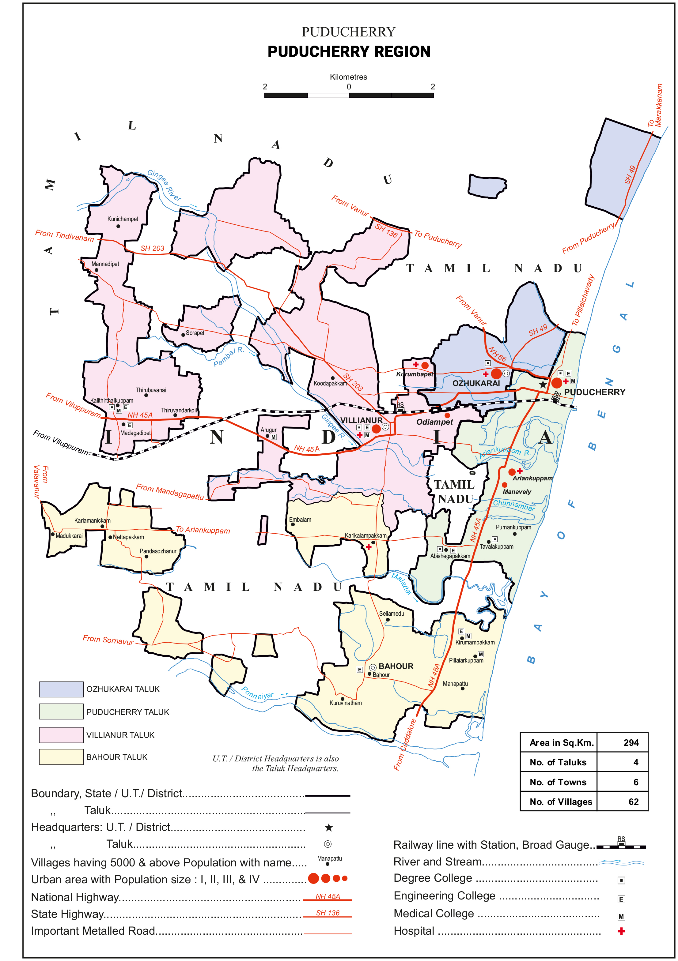
| Area | 294 Sq Km |
| No. of Revenue Disivions | 4 |
| No. of Taluks/Sub-Taluks | 6 |
| No. of Revenue Firkas | 11 |
| No. of Revenue Villages | 62 |
| No. of Gram Panchayats | 71 |
| No. of Municipalities | 5 |
| No. of Commune Panchayats | 5 |
| No. of Census Villages | 62 |
| Total Population | 9,50,289 |
| Male Population | 4,68,258 |
| Female Population | 4,82,031 |
| Total Rural Population | 2,93,080 |
| Rural Male Population | 1,44,769 |
| Rural Female Population | 1,48,311 |
| Urban Total Population | 6,57,209 |
| Urban Male Population | 3,23,489 |
| Urban Female Population | 3,33,720 |
Karaikal DISTRICT
Several explanations are offered for the word ‘Karaikal’. The Imperial Gazetteer gives it the meaning as ‘fish pass’. According to Julien Vinson the town is said to have known as Karaigiri in Sanskrit. However, the name Karaikal is no doubt a combination of two words ‘Karai’ and ‘Kal’ which means ‘lime mix’ and ‘canal’ i.e. a canal built of lime mix. However, no trace of such a canal is evident now.
In 1738, Benoit Dumas, a shrewd calculative prudent man and a lover of peace and above all anxious to extend the French territory in India by smooth means, negotiated with Sahuji(Saiyaji) of Thanjavur for possession of Karaikal, the fortress of Karakalacheri and 5 villages for 40,000 chakras but not materialised. On 14th February 1739 the French took possession of Karaikal town, the fort of Karakalacheri and 8 dependent villages as a gift from Chanda Saheb, the ruler of Trichy who conquered Karaikal. The King of Thanjavur raised the price for the town of Karaikal and the fort of Karakalacheri to 50,000 chakras. He also demanded a loan of 1,50,000 chakras without interest repayable in 3 years against the hypothecation of Mayavaram lands and an annual rent of 4,000 pagodas for 5 villages. The French agreed to all the terms except for the payment of 1,50,000 chakras which was reduced to two or three thousand chakras. The villages so received were Kilaiyur, Melaiyur, Puduthurai, Kovilpathu and Tirumalairayanpattinam. Pratap Singh who succeeded the throne renewed demand for a loan of 1,00,000 chakras and on receipt of the first installment of 4,000 chakras he assigned 8 more villages to the French viz., Codague (Kondagai), Vanjiyur, Arimullimangalam, Neravy, Dharmapuram, Uzhiapathu, Mattakudi (probably Mathalangudi) and Polagam. Then on 12th February 1740, he sold for 60,000 chakras these 8 villages which he had assigned only the previous year for 40,000 chakras. The same year he pledged Thirunallar Mahanam for 55,350 chakras and also pledged 33 villages for 60,000 chakras. By a treaty signed on 12th January 1750, Pratap Singh ceded to the French 81 villages around Karaikal and cancelled the annual rent of 2,000 pagodas payable for the villages. This was all the territory the French possessed around Thanjavur when they surrendered to the British in 1761. The territory then passed twice to the British control before it was finally handed over to the French in 1816 under the Treaty of Paris, 1814.
The formation of Karaikal National Congress on 13th June 1947 and Students Congress on 31st January 1947 symbolized the first concrete expression of popular desire in Karaikal for freedom from French rule. The French ruled this district till 31st October, 1954 and de facto – transfer of power took place on 1st November 1954 followed by de jure-transfer on 16th August, 1962. Even Though the Territory was handed over to the Republic of India on 1st November 1954 Karaikal's municipal administration was continued pursuant to the Arrêté dated 8 March 1880. This was replaced by the promulgation of the Pondicherry Municipality Act, 1973, with effect from 26 January 1974.
Demography
As per Provisional population figures of 2011 Census.
| Demographic Label | Value |
|---|---|
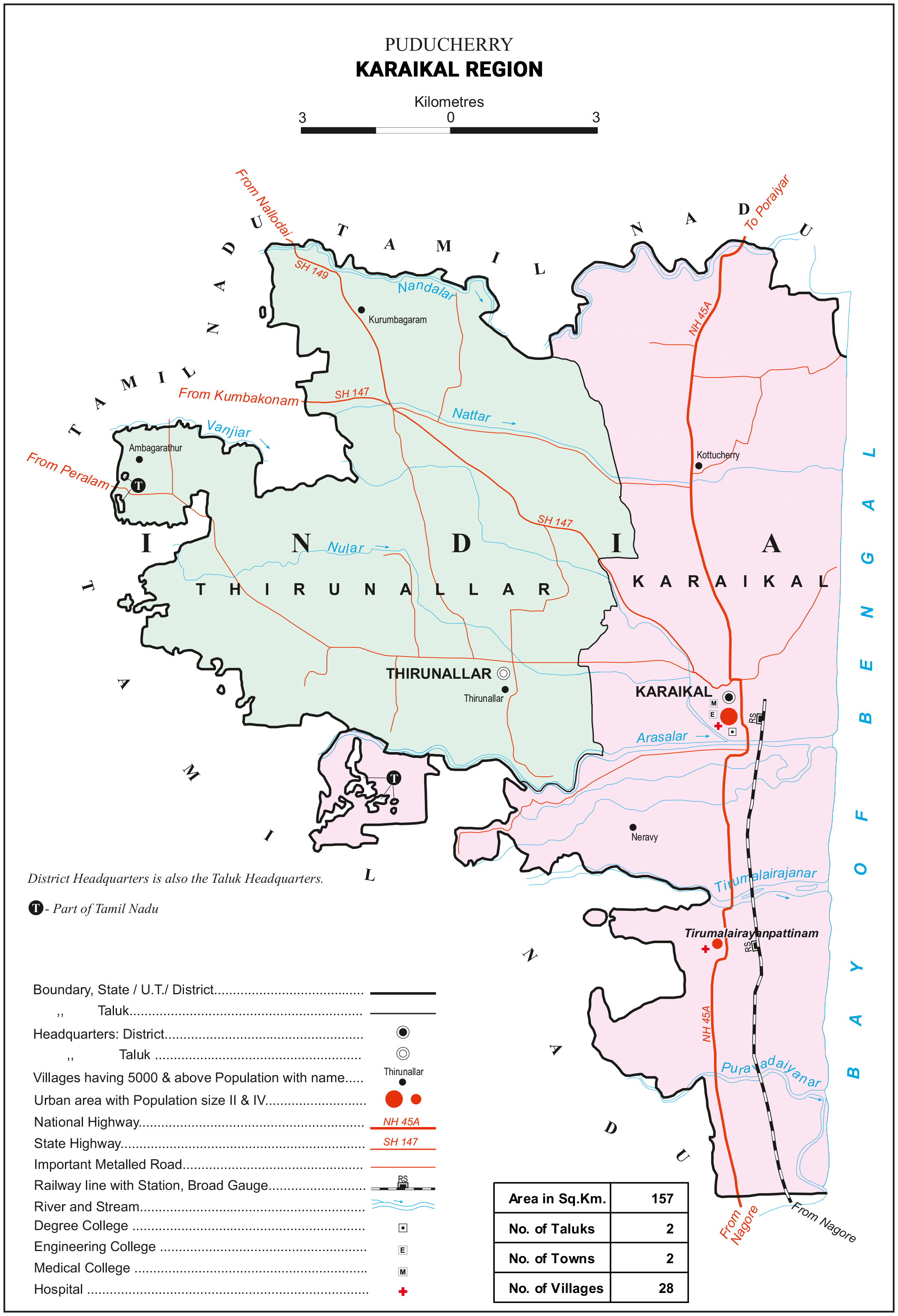
| Area | 161 Sq Km |
| No. of Taluks/Sub-Taluks | 2 |
| No. of Municipalities | 1 |
| No. of Commune Panchayats | 5 |
| Total Population | 2,00,222 |
| Male Population | 97,808 |
| Female Population | 1,02,413 |
| Total Rural Population | 102,120 |
| Rural Male Population | 50,138 |
| Rural Female Population | 51,982 |
| Urban Total Population | 98,102 |
| Urban Male Population | 47,671 |
| Urban Female Population | 50,431 |
Yanam DISTRICT
Yanam district, one among the four Census districts of Puducherry Union Territory, lies on the Bank of Godavari river in the East Godavari district of Andhra Pradesh. Yanam was a Dutch colony before it was occupied by the French in 1723. Yanam was under the French rule for more than two centuries. It is now one of the component part of the Puducherry Union Territory.
The tiny Town’s history goes back to 1723 when the Compagnie des Indes of France established here a trading port of theirs. It was vacated after four years because their commercial operations did not produce the desired results. It was seized again in 1731 during the time of Dupleix. A Parwana from Haji Hassan Khan authorized the French Representative Fouquet, then chief of the company at Machilipatanam which is 325 kms away from Yanam to set up a ‘loge’ Market place at Yanam in the year 1731. Nawab Roustaumkhan granted a Paravana in 1735 for French Commerce in Yanam.
It was re-established completely in 1742 and administered by De Choisis who died here on 27th October 1747. He was succeeded by Sinfray. The annual rent was waived off by a document in 1743 for Yanam. Mir Mohammed Alikhan granted all the rights on the land situated before the quarters at Yanam in 1747. Unfortunately necessary details are not available for this period i.e., from 1723 to 1750. The sovereignty of the French over the territory was confirmed by Musafar Yung, the Nizam of Hyderabad in 1750. Like all other settlements Yanam too fell thrice into the hands of the British. After the Napolenic wars, Yanam along with the factory at Machilipatanam was finally returned to the French early in 1817.
As per the Treaty of Paris, the Nizam handed it over to the French in 1861. Since, then it was ruled by French Government. After independence of the India, The Mahajana Party at Yanam favour the merger of Yanam with India union, while the Socialist Party was against it. However, on 13th June 1954, Yanam was liberated by the leaders of local citizens from the clutches of French regime but officially it was merged with the Indian Union by de facto on 01st November 1954 and de jure on 16th August 1962. In that treaty two countries have exchanged the instruments of rectification under which France had handed over to India full sovereignty over the territory it held. Puducherry and other enclaves, Karaikal, Mahe and Yanam came to be administered as the Union Territory of Puducherry from 1st July 1963.
Demography
As per Provisional population figures of 2011 Census.
| Demographic Label | Value |
|---|---|
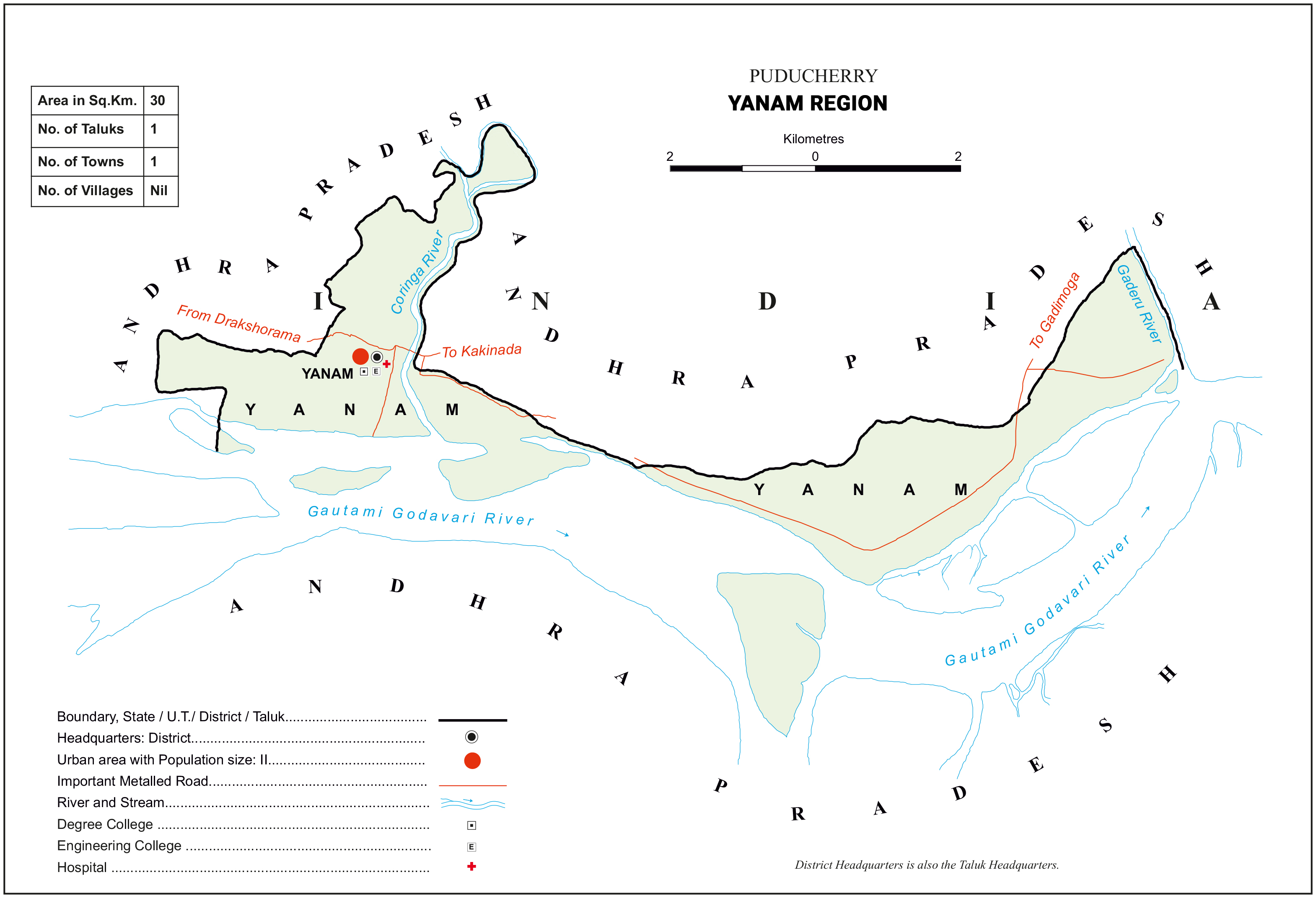
| Area | 30 Sq Km |
| No. of Taluks/Sub-Taluks | 1 |
| No. of Revenue Villages | 6 |
| No. of Municipalities | 1 |
| Total Population | 55,626 |
| Male Population | 27,301 |
| Female Population | 28,325 |
| Total Rural Population | - |
| Rural Male Population | - |
| Rural Female Population | - |
| Urban Total Population | 55,626 |
| Urban Male Population | 27,301 |
| Urban Female Population | 28,325 |
Mahe DISTRICT
Mahe is also known as ‘Mayyazhi’. Mahe district is named after its district head quarter ‘Mahe’. It is a small town surrounded on all sides by Kerala State. The official name of Mahe is ‘Mayyazhi’, in the Malalyalam language meaning “eyebrow of the sea”. In otherwords Mayyazhi means ‘Beautiful Estuary’. The French named this place Mahe in honour of French Commander, Bertrand Francois Mahe de La Bourdonnais ( 1699 – 1753 ), a key architect of French policy in India.
On examining the history of Kerala, no clear evidence is available mentioning the place ‘Mahe’ otherwise called ‘Mayyazhi’. So, it is only the settlement of the French, the name Mahe (Mayyazhi) got a place in the geographical map of India. In annexure, the Martineau’s book referring the Origin of Mahe to the place as Maye only after the recapture of the place by Mahe De Labour dannais.
The French East India Company came to Mahe in 1721. They approached the Vazhunnavar of Badagara, in March 1721 for his permission to open a godown in Mahe. He was hesitant in the beginning. But in September, 1722 the permission was granted as per the treaty signed by the Badagara Vazhunnavar and the representative of the French East India Company. The letter secured monopoly rights in the purchase of pepper from Kadathanadu. The ships of Vazhunnavar would fly the flag of the French East India Company. There was a mutual assurance of military assistance in the event of an attack on any one of the allies.
The British military of Thalassery captured Mahe but in 1725, the French could re-capture it. Mahe remained under the French possession till 1761. In 1739, the British constructed the Fort St. George in a plot of land, bought from a landlord of Iruvazhinadu, for an amount of Rs 8000/- . The treaty between the Badagara Vazhunnavar and the British of the Fort St. George was against the interests of the French. Consequent on the attack of the Kadathanad Army with the help of the British, the French were compelled to leave Mahe and seek refuge in Kozhikode.
In the month of December 1725, a fleet of French Navy, Commanded by Mahe' De Labourdonnais recaptured Mahe. On 8th November, 1726, a compromise treaty was signed. As per the treaty, a large plot of land on the seashore, lying straddled between two hills and accessible through the river Mahe was awarded to the French. In 1739, the Nambiars of Iruvazhinadu handed over the village of Chembra to the French. In 1761, consequent on the war in Europe, the British stationed at Thalassery and captured Mahe. In 1763, a Peace Treaty was signed in Paris and accordingly the French got Mahe back into their possession. Again, in 1779, the British took hold of Mahe which was returned to the French in 1785. The history of Mahe, till 1785 was rife with the conflicts between the British and French colonial powers, either directly or indirectly in league with the local feudal powers. The first municipal council of Mahe came into existence in 1791. It was an arrangement made by the French East India
Demography
As per Provisional population figures of 2011 Census.
| Demographic Label | Value |
|---|---|
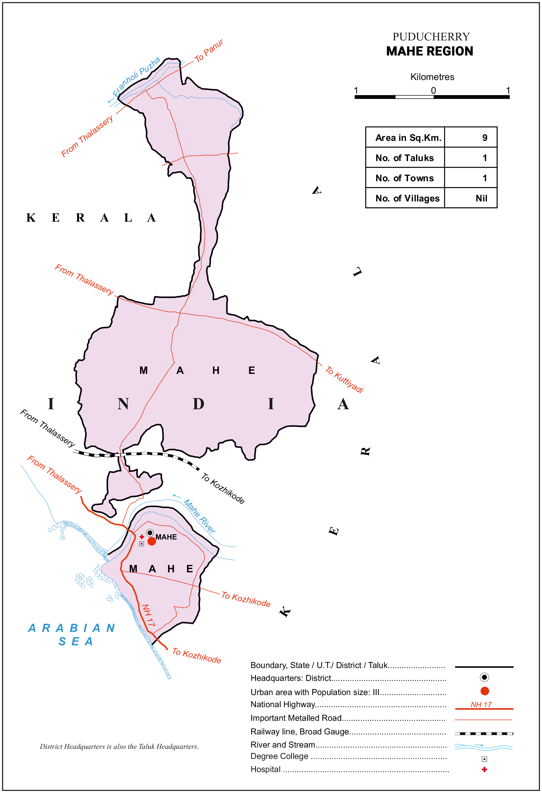
| Area | 9 Sq Km |
| No. of Taluks/Sub-Taluks | 1 |
| No. of Revenue Villages | 5 |
| No. of Municipalities | 1 |
| Total Population | 41,816 |
| Male Population | 19,143 |
| Female Population | 22,673 |
| Total Rural Population | - |
| Rural Male Population | - |
| Rural Female Population | - |
| Urban Total Population | 41,816 |
| Urban Male Population | 19,143 |
| Urban Female Population | 22,673 |